
List of municipalities in Álava

.png)
Álava-Araba is a province in the autonomous community of the Basque Country, Spain. It is divided into 51 municipalities.[1] According to the 2011 Spanish Census, the province is the 41st largest by population with 320,788 inhabitants but is the 48th largest by land area spanning 2,963 square kilometres (1,144 sq mi).[1]
Each municipality forms part of a province which in turn forms part or the whole of an autonomous community. The organisation of the municipalities is governed by a 2 April 1985 law, completed by the 18 April 1986 royal decree. The Statutes of Autonomy of the various autonomous communities also contain provisions concerning the relations between the municipalities and the autonomous governments. In general, municipalities enjoy a large degree of autonomy in their local affairs: many of the functions of the comarcas and provinces are municipal powers pooled together. Each municipality is a corporation with independent legal personality: its governing body is called the ayuntamiento (municipal council or corporation), a term often also used to refer to the municipal offices (city and town halls). The ayuntamiento is composed of the mayor (Spanish: alcalde), the deputy mayors (Spanish: tenientes de alcalde) and the plenary assembly (pleno) of councillors (concejales). The mayor and the deputy mayors are elected by the plenary assembly, which is itself elected by universal suffrage on a list system every four years. The plenary assembly must meet publicly at least every three months at the seat of the ayuntamiento. Many ayuntamientos also have a governing commission (comisión de gobierno), named by the mayor from among the councillors; it is required for municipalities of more than 5,000 inhabitants. The governing commission, whose role is to assist the mayor between meetings of the plenary assembly, may not include more than one third of the councillors.
Municipalities
[edit]- Largest municipalities in Araba/Álava by population
-
 Vitoria-Gasteiz is the province's capital and largest municipality by population
 -
 Laudio/Llodio, the second largest municipality by population in Araba/Álava
 -
 Amurrio is Araba/Álava's third largest municipality by population
 -
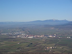 Salvatierra/Agurain, Araba/Álava's fourth largest municipality by population


| Name | Cuadrilla[2] | Population (2023 census)[3] |
Population (2011 census)[1] |
Change | Land area (km²)[4] | Population density (2023) |
|---|---|---|---|---|---|---|
| Alegría-Dulantzi | Llanada Alavesa/Arabako Lautada | 2,969 | 2,860 | +3.8% | 19.95 | 148.8/km2 |
| Amurrio | Ayala/Aiara | 10,299 | 10,071 | +2.3% | 96.30 | 106.9/km2 |
| Añana | Añana | 156 | 165 | −5.5% | 21.92 | 7.1/km2 |
| Aramaio | Gorbeialdea | 1,409 | 1,507 | −6.5% | 73.09 | 19.3/km2 |
| Armiñón | Añana | 233 | 227 | +2.6% | 12.97 | 18.0/km2 |
| Arraia-Maeztu | Montaña Alavesa/Arabako Mendialdea | 812 | 739 | +9.9% | 123.11 | 6.6/km2 |
| Arrazua-Ubarrundia | Gorbeialdea | 1,042 | 953 | +9.3% | 57.53 | 18.1/km2 |
| Asparrena | Llanada Alavesa/Arabako Lautada | 1,607 | 1,691 | −5.0% | 65.11 | 24.7/km2 |
| Artziniega | Ayala/Aiara | 1,832 | 1,854 | −1.2% | 27.29 | 67.1/km2 |
| Ayala/Aiara | Ayala/Aiara | 2,918 | 2,894 | +0.8% | 140.97 | 20.7/km2 |
| Baños de Ebro/Mañueta | Laguardia-Rioja Alavesa/Biasteri Arabako Errioxa | 298 | 314 | −5.1% | 9.50 | 31.4/km2 |
| Barrundia | Llanada Alavesa/Arabako Lautada | 895 | 904 | −1.0% | 97.30 | 9.2/km2 |
| Berantevilla | Añana | 458 | 480 | −4.6% | 35.75 | 12.8/km2 |
| Bernedo | Montaña Alavesa/Arabako Mendialdea | 539 | 572 | −5.8% | 130.48 | 4.1/km2 |
| Campezo/Kanpezu | Montaña Alavesa/Arabako Mendialdea | 1,079 | 1,146 | −5.8% | 85.36 | 12.6/km2 |
| Elburgo/Burgelu | Llanada Alavesa/Arabako Lautada | 637 | 624 | +2.1% | 32.10 | 19.8/km2 |
| Elciego | Laguardia-Rioja Alavesa/Biasteri Arabako Errioxa | 968 | 1,048 | −7.6% | 16.26 | 59.5/km2 |
| Elvillar/Bilar | Laguardia-Rioja Alavesa/Biasteri Arabako Errioxa | 314 | 363 | −13.5% | 17.50 | 17.9/km2 |
| Harana/Valle de Arana | Montaña Alavesa/Arabako Mendialdea | 218 | 283 | −23.0% | 39.12 | 5.6/km2 |
| Iruña Oka/Iruña de Oca | Añana | 3,600 | 3,043 | +18.3% | 53.24 | 67.6/km2 |
| Iruraiz-Gauna | Llanada Alavesa/Arabako Lautada | 540 | 540 | 0.0% | 47.13 | 11.5/km2 |
| Kripan | Laguardia-Rioja Alavesa/Biasteri Arabako Errioxa | 176 | 196 | −10.2% | 12.52 | 14.1/km2 |
| Kuartango | Añana | 401 | 355 | +13.0% | 84.32 | 4.8/km2 |
| Labastida/Bastida | Laguardia-Rioja Alavesa | 1,577 | 1,489 | +5.9% | 38.11 | 41.4/km2 |
| Lagrán | Montaña Alavesa/Arabako Mendialdea | 172 | 182 | −5.5% | 45.62 | 3.8/km2 |
| Laguardia | Laguardia-Rioja Alavesa/Biasteri Arabako Errioxa | 1,486 | 1,541 | −3.6% | 80.94 | 18.4/km2 |
| Lanciego/Lantziego | Laguardia-Rioja Alavesa/Biasteri Arabako Errioxa | 708 | 690 | +2.6% | 24.25 | 29.2/km2 |
| Lantarón | Añana | 937 | 909 | +3.1% | 67.45 | 13.9/km2 |
| Lapuebla de Labarca | Laguardia-Rioja Alavesa/Biasteri Arabako Errioxa | 869 | 859 | +1.2% | 6.05 | 143.6/km2 |
| Laudio/Llodio | Ayala/Aiara | 17,910 | 18,461 | −3.0% | 37.73 | 474.7/km2 |
| Legutiano | Gorbeialdea | 2,043 | 1,739 | +17.5% | 45.86 | 44.5/km2 |
| Leza | Laguardia-Rioja Alavesa/Biasteri Arabako Errioxa | 220 | 222 | −0.9% | 9.92 | 22.2/km2 |
| Moreda de Álava | Laguardia-Rioja Alavesa/Biasteri Arabako Errioxa | 208 | 248 | −16.1% | 8.67 | 24.0/km2 |
| Navaridas | Laguardia-Rioja Alavesa/Biasteri Arabako Errioxa | 198 | 223 | −11.2% | 8.92 | 22.2/km2 |
| Okondo | Ayala/Aiara | 1,196 | 1,159 | +3.2% | 29.85 | 40.1/km2 |
| Oyón-Oion | Laguardia-Rioja Alavesa/Biasteri Arabako Errioxa | 3,462 | 3,283 | +5.5% | 45.18 | 76.6/km2 |
| Peñacerrada-Urizaharra | Montaña Alavesa/Arabako Mendialdea | 303 | 278 | +9.0% | 62.15 | 4.9/km2 |
| Erriberagoitia/Ribera Alta | Añana | 826 | 787 | +5.0% | 119.82 | 6.9/km2 |
| Ribera Baja/Erribera Beitia | Añana | 1,430 | 1,311 | +9.1% | 25.31 | 56.5/km2 |
| Salvatierra/Agurain | Llanada Alavesa/Arabako Lautada | 5,078 | 4,937 | +2.9% | 37.77 | 134.4/km2 |
| Samaniego | Laguardia-Rioja Alavesa/Biasteri Arabako Errioxa | 305 | 334 | −8.7% | 10.58 | 28.8/km2 |
| San Millán/Donemiliaga | Llanada Alavesa | 730 | 720 | +1.4% | 85.39 | 8.5/km2 |
| Urkabustaiz | Gorbeialdea | 1,434 | 1,355 | +5.8% | 60.85 | 23.6/km2 |
| Valdegovía/Gaubea | Añana | 1,064 | 1,079 | −1.4% | 238.23 | 4.5/km2 |
| Villabuena de Álava/Eskuernaga | Laguardia-Rioja Alavesa/Biasteri Arabako Errioxa | 284 | 330 | −13.9% | 8.48 | 33.5/km2 |
| Vitoria-Gasteiz† | Vitoria-Gasteiz | 255,423 | 240,753 | +6.1% | 276.98 | 922.2/km2 |
| Yécora/Iekora | Laguardia-Rioja Alavesa | 250 | 286 | −12.6% | 18.80 | 13.3/km2 |
| Zalduondo | Llanada Alavesa/Arabako Lautada | 196 | 185 | +5.9% | 11.89 | 16.5/km2 |
| Zambrana | Añana | 423 | 434 | −2.5% | 39.57 | 10.7/km2 |
| Zigoitia | Gorbeialdea | 1,819 | 1,740 | +4.5% | 102.09 | 17.8/km2 |
| Zuia | Gorbeialdea | 2,357 | 2,420 | −2.6% | 122.58 | 19.2/km2 |
| Araba/Álava | — | 336,308[5] | 320,778[6] | +4.8% | 2,967.86 | 113.3/km2 |
| Basque Country | — | 2,216,302[5] | 2,185,393[6] | +1.4% | 7,092.45 | 312.5/km2 |
| Spain | — | 48,085,361[5] | 46,815,916[6] | +2.7% | 504,729.70 | 95.3/km2 |
See also
[edit]References
[edit]- ^ a b c "Censos de Población y Viviendas 2011. Resultados Municipales - Cuenca. Población por municipios, sexo y edad (año a año)" (in Spanish). National Statistics Institute. Retrieved 18 July 2024.
- ^ BOTHA 2021, p. 1.
- ^ "Censo anual de población 2021-2023. Resultados por municipios. 2021-2023. Población por sexo, edad (grupos quinquenales) y nacionalidad (española/extranjera)" (in Spanish). National Statistics Institute. Retrieved 19 July 2024.
- ^ "Nomenclátor Geográfico de Municipios y Entidades de Población" (in Spanish). Centro Nacional de Información Geográfica. Retrieved 14 July 2024.
- ^ a b c "Censo anual de población 2021-2023. Resultados nacionales, por comunidades autónomas y provincias. 2021-2023. Población por sexo, edad (año a año) y nacionalidad (española/extranjera)" (in Spanish). National Statistics Institute. Retrieved 18 July 2024.
- ^ a b c "Censos de Población y Viviendas 2011. Resultados Nacionales, por Comunidades Autónomas y Provincias. Población según comunidad autónoma y provincia y sexo" (in Spanish). National Statistics Institute. Retrieved 18 July 2024.
Works cited
[edit]- "Norma Foral 3/2021, de 10 de febrero, de modificación de la Norma Foral 63/1989, de 20 de noviembre, de Cuadrillas del Territorio Histórico de Álava" (PDF). Boletín Oficial del Territorio Histórico de Álava (in Spanish). 19 February 2021. Retrieved 22 July 2024.
{{cite journal}}: CS1 maint: date and year (link)